Tjek vores relaterede varer herunder, eller brug søgefeltet og menuen til at finde præcis det, du leder efter.
Beskrivelse
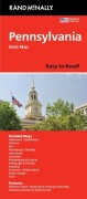
Rand McNally's Easy To Read State Folded Map is a must-have for anyone traveling in and around Pennsylvania, offering unbeatable accuracy and reliability at a great price. Our trusted cartography shows all Interstate, U. S., state, and county highways, along with clearly indicated parks, points of interest, airports, county boundaries, and streets.
The easy-to-use legend and detailed index make for quick and easy location of destinations. You'll see why Rand McNally folded maps have been the trusted standard for years. - Regularly updated, full-color maps. - 40% larger map with a bigger type size than the Rand McNally Folded Map. - Clearly labeled Interstate, U. S., state, and county highways.
Indications of parks, points of interest, airports, county boundaries, and more. - Mileage and driving times map. - Detailed index. Coverage Area Detailed maps of: Allentown/Bethlehem, Altoona, Erie, Gettysburg, Harrisburg, Johnstown, Lancaster, Philadelphia & Vicinity, Downtown Philadelphia, Pittsburgh & Vicinity, Downtown Pittsburgh, Reading, Scranton/Wilkes-Barre, York. 1:400.000
Yderligere information
| Kategori | Bøger |
|---|---|
| Genre(r) | Rejsebøger |
| Forlag | Rand Mcnally |
| Udgivelsesdato | Er udgivet |
| Sprog | Engelsk |
| ISBN-13 | 9780528028779 |
| ISBN-10 | 0528028774 |
| Indbinding | Falset |
| Tags | Pennsylvania State Map, Bøger, Bog |
| GPSR | Produktsikkerhed |